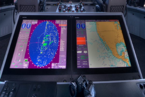
It is a navigation system that works with computers, which can be an alternative to paper maps, which are determined by IMO rules and fully dependent on the relevant rules. We can also say that the use of some simultaneous information with ECDIS, the status of the ship's position, the distance of the ship to the land, the ship's navigational aids or the automatic updating of invisible dangers, is a kind of decision aid. The ECDIS system, which accesses the ENC, that is, the navigation map, and also some navigation sensors with GPS, is very important for a ship.
WHAT ARE THE BENEFITS OF ECDIS?
When the Ecdis system is used by people specially trained on the system, it brings many additional & important benefits to the Ship's crew. Awareness will increase with this system, which can be used in a wide area depending on the person using it. Considering the important benefits;
* The backup navigation system can be integrated into the ECDIS system and provides a lot of navigational benefits.
* Provides more efficiency the ship's voyage plan, supports people to evaluate their voyage plans and to reduce the time.
* Provides fast and efficient ship map corrections. It relieves a lot of the burden on the officer of navigation.
* All manual map corrections will tire you out. Thanks to Ecdis, long expedition plans are eliminated. You are less tired.
ELECTRONIC CHART DISPLAY AND INFORMATION SYSTEM (ECDIS)
We can say that this system, also known as the Electronic Chart Display System, is the common point of all electronic ship navigation devices on the bridge. It is a kind of support for the reception of common information, the position of the ship and other issues. Ecdis does not only show the electronic map, it can also access the information provided by almost every navigation device on the bridge, and also offers you navigational safety. It is convenient to connect devices such as DGPS, Radar, Sounder (Echo Sounder), AIS, Gyro Compass (Gyro Compass), Longline (Dopler Speed Log), Navtex to ECDIS. It is one of the most preferred systems by captains in terms of navigational safety.
HISTORY OF ECDIS
The studies initiated by the International Hydrographic Office (IHO) and the International Maritime Organization (IMO) in the 1980s have accelerated the efforts to make electronic maps safe and to develop navigational devices over time, and the shift of seafarers to safer and healthier systems by moving away the old systems in paper form. intended.
All ships on 500 Gross tanage are required to have electronic charts. Apart this, all ships should also have a system that can take backup.
Information continues for you on the Blue Octopus corporate website. You can always contact us to get more information after reading the content of the Electronic Map Display System you have examined. You can reach our company the phone or e-mail addresses on the website you have examined for the issues and all questions that come to your mind.


 share
share twitt
twitt share
share share
share